サントメ・プリンシペの空港の一覧
本項ではサントメ・プリンシペの空港の一覧を所在地順に示す。
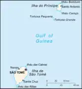
サントメ・プリンシペの地図
.jpg.webp)
ギニア湾におけるサントメ・プリンシペの位置
サントメ・プリンシペ(正式名称はサントメ・プリンシペ民主共和国)はアフリカ大陸西部の赤道沿岸であるギニア湾に位置する島国でポルトガル語が公用語であり、サントメ島とプリンシペ島の2つの島で構成されていて、ガボンの北西部海岸からそれぞれ約140キロメートル (87 mi)、約250 and 225キロメートル (155 and 140 mi)離れている上、赤道ギニア領であるアンノボン島とビオコ島に挟まれている。サントメ・プリンシペは7つの県があるが、サントメ島に6県、プリンシペ島は全体で1つの県である。首都はサントメである。
空港
| 都市 | 島 | ICAO | IATA | 空港名 | 地理座標 |
|---|---|---|---|---|---|
| ポルトアレグレ | サントメ島 | FPPA | PGP | ポルトアレグレ空港 | 北緯00度02分 東経006度31分 |
| サント・アントニオ | プリンシペ島 | FPPR | PCP | プリンシペ空港 | 北緯01度39分46秒 東経007度24分42秒 |
| サントメ | サントメ島 | FPST | TMS | サントメ国際空港 | 北緯00度22分41秒 東経006度42分44秒 |
関連項目
- サントメ・プリンシペの交通
- ICAO空港コードの一覧/F#FP – サントメ・プリンシペ
脚注
外部リンク
- "ICAO Location Indicators by State" (PDF). International Civil Aviation Organization. 12 January 2006. Cite webテンプレートでは
|access-date=引数が必須です。 (説明) - "UN Location Codes: São Tomé and Príncipe". UN/LOCODE 2009-2. UNECE. 8 February 2010. Cite webテンプレートでは
|access-date=引数が必須です。 (説明) - includes IATA codes - Great Circle Mapper: Airports in São Tomé and Príncipe - IATA and ICAO codes, coordinates
- World Aero Data: Airports in São Tomé and Príncipe - ICAO codes and coordinates
This article is issued from Wikipedia. The text is licensed under Creative Commons - Attribution - Sharealike. Additional terms may apply for the media files.