サント・アントニオ
サント・アントニオ(Santo António)は、サントメ・プリンシペの都市。プリンシペ島北部にあり、プリンシペ島最大の都市である。人口1342人(2012年)[1]。プリンシペ州の州都ならびにパグエ県の県都である。1471年に建設された。
| サント・アントニオ | |
|---|---|
| 位置 | |
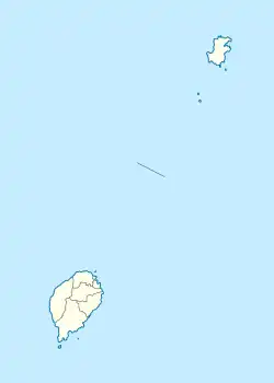 サント・アントニオ サント・アントニオ (サントメ・プリンシペ)  サント・アントニオ サント・アントニオ (プリンシペ)  サント・アントニオ サント・アントニオ (アフリカ) | |
| 座標 : 北緯1度38分12秒 東経7度25分04秒 | |
| 行政 | |
| 国 | |
| 州 | プリンシペ州 |
| 県 | パグエ県 |
| 町 | サント・アントニオ |
| 人口 | |
| 人口 | (2012年現在) |
| 町域 | 2,620人 |
| その他 | |
| 等時帯 | グリニッジ標準時 (UTC+0) |
気候
| サント・アントニオの気候 | |||||||||||||
|---|---|---|---|---|---|---|---|---|---|---|---|---|---|
| 月 | 1月 | 2月 | 3月 | 4月 | 5月 | 6月 | 7月 | 8月 | 9月 | 10月 | 11月 | 12月 | 年 |
| 平均最高気温 °C (°F) | 27 (80) |
28 (83) |
29 (84) |
29 (84) |
28 (82) |
27 (80) |
26 (79) |
26 (78) |
26 (79) |
27 (80) |
27 (80) |
27 (81) |
27.3 (80.8) |
| 平均最低気温 °C (°F) | 26 (79) |
27 (81) |
28 (82) |
28 (82) |
27 (80) |
26 (78) |
24 (76) |
24 (75) |
24 (76) |
26 (78) |
27 (80) |
27 (80) |
26.2 (78.9) |
| 降水量 cm (inch) | 130 (5) |
107 (4.2) |
180 (7) |
246 (9.7) |
310 (12.2) |
89 (3.5) |
23 (0.9) |
46 (1.8) |
180 (7.1) |
360 (14) |
188 (7.4) |
99 (3.9) |
1,958 (76.7) |
| 出典:Weatherbase [2] | |||||||||||||
交通
空港
脚注
This article is issued from Wikipedia. The text is licensed under Creative Commons - Attribution - Sharealike. Additional terms may apply for the media files.