スワコプムント
スワコプムント(ドイツ語: Swakopmund)はナミビアの大西洋に面した都市である。人口は28,552人(2007年).[3] 。エロンゴ州の州都でもある。
スワコプムント | ||
|---|---|---|
|
City | ||
| Swakopmund | ||
.jpg.webp) スワコプムント全景 | ||
| ||
|
標語: Providentiae memor | ||
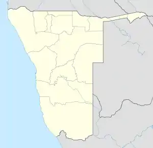 スワコプムント Location in Namibia | ||
| 座標:南緯22度41分 東経14度32分 | ||
| 国 |
| |
| 州 | エロンゴ州 | |
| 選挙区 | スワコプムント選挙区 | |
| 建設 | 1892年8月4日 | |
| 政府 | ||
| • 市長 | Paulina Ndahafa Nashilundo | |
| 面積 | ||
| • 合計 | 196.3 km2 | |
| 人口 | ||
| • 合計 | 44,725人 | |
| • 密度 | 227.8人/km2 | |
| 等時帯 | UTC+2 (中央アフリカ時間) | |
| 気候 | 砂漠気候 | |
| ウェブサイト |
swakop | |

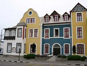
スワコプムントの家
歴史
1892年にドイツ領南西アフリカの主要港として建設された。
| スワコプムント | ||||||||||||||||||||||||||||||||||||||||||||||||||||||||||||
|---|---|---|---|---|---|---|---|---|---|---|---|---|---|---|---|---|---|---|---|---|---|---|---|---|---|---|---|---|---|---|---|---|---|---|---|---|---|---|---|---|---|---|---|---|---|---|---|---|---|---|---|---|---|---|---|---|---|---|---|---|
| 雨温図(説明) | ||||||||||||||||||||||||||||||||||||||||||||||||||||||||||||
| ||||||||||||||||||||||||||||||||||||||||||||||||||||||||||||
| ||||||||||||||||||||||||||||||||||||||||||||||||||||||||||||
交通
道路
脚注
- “Table 2.1 Population density by area”. 2011 Population and Housing Census - Erongo Regional Profile. Namibia Statistics Agency. p. 4. 2017年9月16日閲覧。
- “Table 4.2.2 Urban population by Census years (2001 and 2011)”. Namibia 2011 - Population and Housing Census Main Report. Namibia Statistics Agency. p. 39. 2017年9月16日閲覧。
- “Swakopmund”. World Gazetteer. 2007年9月30日時点のオリジナルよりアーカイブ。2007年7月1日閲覧。
関連項目
This article is issued from Wikipedia. The text is licensed under Creative Commons - Attribution - Sharealike. Additional terms may apply for the media files.