カンバート湾
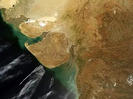
カンバート湾(ヒンディー語: खंभात की खाड़ी Khambhāt kī khāṛī, 英語: Gulf of Khambhat)、カンバト湾、またはカンベイ湾(कैंबे की खाड़ी, Gulf of Cambay)はインドのグジャラート州にある、アラビア海の湾[1]。
拡大
Clip
長さ約200km、幅は約20km(北部)から70km(南部)である。主な流入河川はナルマダー川、タプティ川、マヒ川、サバルマティ川[2]。
湾はカーティヤーワール半島とグジャラート州南東部とを隔てている[3][4][5]。
湾を横切る、長さ30kmのダムを建設する計画がある[6]。
関連項目
- カンバート湾の考古遺跡 - 2001年に発見された水没した古代都市
脚注
- Chisholm, Hugh, ed. (1911). . Encyclopædia Britannica (英語) (11th ed.). Cambridge University Press.
- Saha, S., Banerjee, S., Burley, S.D., Ghosh, A. and Saraswati, P.K. (2010). The influence of flood basaltic source terrains on the efficiency of tectonic setting discrimination diagrams: an example from the Gulf of Khambhat, western India. Sedimentary Geology 228 (1): 1–13.
- Nowell, K.; Jackson, P. (1996). “Panthera Leo”. Wild Cats: Status Survey and Conservation Action Plan. Gland, Switzerland: IUCN/SSC Cat Specialist Group. pp. 17–21. ISBN 2-8317-0045-0
- Trivedi, P. and Soni, V. C. (2012). Significant bird records and local extinctions in Purna and Ratanmahal Wildlife Sanctuaries, Gujarat, India
- Jhala, Y. V., Qureshi, Q., Sinha, P. R. (Eds.) (2011). Status of tigers, co-predators and prey in India, 2010. National Tiger Conservation Authority, Government of India, New Delhi, and Wildlife Institute of India, Dehradun. TR 2011/003.
- “The Gulf of Khambhat Development Project”. Gujarat. 2013年5月18日閲覧。
This article is issued from Wikipedia. The text is licensed under Creative Commons - Attribution - Sharealike. Additional terms may apply for the media files.