アルーラ
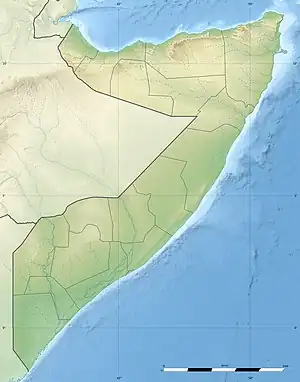
アルーラ(Alula, Aluula, ソマリ語: Caluula, アラビア語: علولة) はソマリア連邦の構成国プントランド北部にある港町。ソマリアの行政区画ではバリ地域に当たるが、プントランドはアルーラ周辺をバリ地域から独立させてガルダフル地域としている。
アルーラ Caluula علولة | |
|---|---|
|
City | |
| Alula | |
 アルーラ  アルーラ | |
| 座標:北緯11度58分0秒 東経50度45分0秒 | |
| 連邦 |
|
| 構成国 |
|
| 地域 | バリ地域 |
| 地区 | アルーラ地区 |
| 政府 | |
| • 種別 | 地方政府 |
| 等時帯 | UTC+3 (EAT) |
アルーラ周辺は山に囲われており、プントランド中心部から陸路で行くのは困難である。重病人は海路で12時間以上かけて西の港町ボサソにまで運ぶ必要がある。病気以外でも、プントランドの行政サービスが少ない[1]。
歴史
古代
アルーラはアフリカ大陸北東の先端、いわゆるアフリカの角の北端に当たるグアルダフィ岬の近くにあり、古代から交易の要所であった。
アルーラの東20kmの海岸に、ソマリア北東部で最大規模となる24m×17mの大きさの石で縁取られた墓があり、この近くには石敷きの遺跡もある[2]。
1世紀後半にギリシア人航海者が書いたと言われる交易ガイドブック「エリュトゥラー海案内記」には、大きな月桂樹の木立があるアカナイ(Akannai)という町が登場し、これが今日のアルーラと見られる[3]。
近世
1800年代半ばから1900年代初頭にかけて、アルーラはマジェルテーン氏族の国の首都として機能していた[4]。

1886年3月、ドイツ東アフリカ会社は、マジェルテーン氏族の長であるオスマン・マハムドと、アルーラでベルベラからラス・アスラドまでの領域を、ドイツの保護領とする条約を結んだ[5]:234。ドイツはイギリス政府の了解を求めたが、イギリス政府は東経49度(後の英領ソマリランドの東限)はすでにイギリスの保護領であるとした[5]:236。
ソマリア内戦後
2001年10月、アルーラを含めたプントランド北部では深刻な水不足となった[6]。
2008年9月、フランス人夫婦が乗った小型船がアデン湾でソマリア沖の海賊に拉致され、アルーラ近くの山岳地帯に連れていかれた[7]。
2009年6月の日本の参議院外交防衛委員会の参考人意見として、アルーラはボサソ、エイル、ハラデレ、ホビョと共にソマリアにおける5つの海賊の拠点として挙げられた[8]。
2009年11月、アルーラの近くで漁船がフランス海軍に攻撃され、2人死亡した。アルーラ地区知事のIss Omarによれば、攻撃された漁船に海賊の疑いが無かったとのこと[9]。
2013年7月、プントランド政府はアルーラ周辺をガルダフル地域としてバリ地域から分離した[10]。
2017年3月、ジブチからモガディシュに向かう石油タンカーがソマリア沖の海賊に乗っ取られ、アルーラの方面に拉致された[11]。地元の長老の話によれば、外国のトロール船により漁場が破壊されたため、若い漁師が欲求不満のため海賊行為に走るとのことだった[12]。
2017年7月、4月からの天候不良が原因で、アルーラの半分が洪水被害似合い、海岸近くでは海水に浸かる地域も多かった[13]。
2019年11月、サイクロン・パワンによりソマリア北部が大きな被害を受け、アルーラ地区もまた被害を受けた[14]。12月、プントランド副大統領のアフメド・イルミ・イスマンが救援活動の一環でアルーラを訪問[15]。
市長
交通
アルーラには滑走路が未舗装ではあるがアルーラ空港がある[21]。
気候
アルーラは砂漠気候であり、ケッペンの気候区分ではBWhに当たる。
| Alulaの気候 | |||||||||||||
|---|---|---|---|---|---|---|---|---|---|---|---|---|---|
| 月 | 1月 | 2月 | 3月 | 4月 | 5月 | 6月 | 7月 | 8月 | 9月 | 10月 | 11月 | 12月 | 年 |
| 最高気温記録 °C (°F) | 31.6 (88.9) |
31.0 (87.8) |
36.0 (96.8) |
37.5 (99.5) |
38.3 (100.9) |
39.0 (102.2) |
40.5 (104.9) |
40.0 (104) |
38.0 (100.4) |
36.0 (96.8) |
31.6 (88.9) |
31.0 (87.8) |
40.5 (104.9) |
| 平均最高気温 °C (°F) | 26.9 (80.4) |
26.9 (80.4) |
29.5 (85.1) |
31.9 (89.4) |
33.5 (92.3) |
34.8 (94.6) |
36.0 (96.8) |
35.3 (95.5) |
33.8 (92.8) |
30.8 (87.4) |
28.3 (82.9) |
27.4 (81.3) |
31.4 (88.5) |
| 日平均気温 °C (°F) | 24.0 (75.2) |
23.6 (74.5) |
25.5 (77.9) |
27.6 (81.7) |
28.9 (84) |
30.2 (86.4) |
31.0 (87.8) |
30.6 (87.1) |
29.2 (84.6) |
26.0 (78.8) |
24.4 (75.9) |
25.4 (77.7) |
27.2 (81) |
| 平均最低気温 °C (°F) | 21.2 (70.2) |
20.5 (68.9) |
21.6 (70.9) |
23.3 (73.9) |
24.5 (76.1) |
25.7 (78.3) |
26.4 (79.5) |
26.0 (78.8) |
24.8 (76.6) |
21.2 (70.2) |
20.6 (69.1) |
21.5 (70.7) |
23.1 (73.6) |
| 最低気温記録 °C (°F) | 15.5 (59.9) |
15.0 (59) |
16.0 (60.8) |
14.0 (57.2) |
16.0 (60.8) |
20.0 (68) |
22.0 (71.6) |
21.0 (69.8) |
20.0 (68) |
14.0 (57.2) |
15.0 (59) |
15.0 (59) |
14.0 (57.2) |
| 降水量 mm (inch) | 0 (0) |
0 (0) |
0 (0) |
0 (0) |
0 (0) |
0 (0) |
0 (0) |
0 (0) |
0 (0) |
0 (0) |
14 (0.55) |
1 (0.04) |
16 (0.63) |
| 平均降水日数 (≥0.1 mm) | 0 | 0 | 0 | 0 | 0 | 0 | 0 | 0 | 0 | 0 | 2 | 0 | 3 |
| % 湿度 | 74 | 72 | 72 | 73 | 71 | 69 | 66 | 70 | 72 | 70 | 74 | 75 | 71 |
| 出典:Deutscher Wetterdienst[22] | |||||||||||||
脚注
- “CIVIL PROTESTS IN GARDAFUU REGION OF PUNTLAND”. wardheernews.com. (2020年6月11日) 2022年4月14日閲覧。
- Chittick, Neville (1975). An Archaeological Reconnaissance of the Horn: The British-Somali Expedition. pp. 117–133
- Casson, Lionel (1986). The Location of Tabai (Periplus Maris Erythraei 12-13). 106. pp. 179-182 2022年4月10日閲覧。.
- Hess, Robert L. (1966). Italian colonialism in Somalia. University of Chicago Press. p. 127
- Mohamed Osman Omar (2009年). “The scramble in the Horn of Africa. History of Somalia (1827-1977)”. 2021年11月25日閲覧。
- “Puntland warns of water shortages”. thenewhumanitarian.org. (2001年10月17日) 2022年4月13日閲覧。
- “Ajnabi lagu haysto Puntland”. bbc.com. (2008年9月10日) 2022年4月16日閲覧。
- 国会図書館 (2009年6月16日). “第171回国会 参議院 外交防衛委員会 第19号 平成21年6月16日”. 2022年4月17日閲覧。
- “Kalluumeysato weerar lagu dilay”. bbc.com. (2009年11月1日) 2022年4月15日閲覧。
- “Somalia: Puntland Parliament Approves New Region and Cabinet Members”. allafrica.com. (2013年7月21日) 2022年4月14日閲覧。
- “Pirates Seize Oil Tanker Off Coast of Somalia”. nytimes.com. (2017年3月14日) 2022年4月13日閲覧。
- “Somalis consider piracy again, blaming illegal fishing trade”. somalilandhorta.com. (2017年3月15日) 2022年4月14日閲覧。
- “Badda oo ku fatahday Degmo ka tirsan Puntland & Qeyb ka mida isu bedeshay Bad”. goobjooge.net. (2017年7月24日) 2022年4月13日閲覧。
- “Over 200,000 people affected by tropical cyclone Pawan in Somalia- Red Cross”. somalilandhorta.com. (2019年12月21日) 2022年4月14日閲覧。
- “Sawiro:Madaxwayne Ku-xigeenka Puntland oo Gaaray degmada Caluula”. gedotimes.com. (2019年12月23日) 2022年4月16日閲覧。
- “Lamaane Faransiis ah oo budhcadii soo afduubtay ay la galeen Buuraha ku dhow xeebaha Puntland”. haatuf.net. (2008年9月8日) 2022年4月15日閲覧。
- “Degmada Caluula oo gole deegaan loo dhisay”. garoweonline.com. (2014年12月23日) 2022年4月16日閲覧。
- “Somalia: Puntland DC says ready to locally fight illegal fishing”. garoweonline.com. (2015年11月5日) 2022年4月17日閲覧。
- “Witnesses in Somalia Report Sinking Ship After Explosion”. voanews.com. (2017年6月26日) 2022年4月13日閲覧。
- “Somali pirates suspected of first ship hijacking since 2012”. bbc.com. (2017年3月14日) 2022年4月13日閲覧。
- “Alula (ALU) Somalia”. World Airport Codes. 2013年7月28日閲覧。
- “Klimatafel von Alula / Somalia” (German). Baseline climate means (1961-1990) from stations all over the world. Deutscher Wetterdienst. 2016年10月22日閲覧。